


pussy les chaux et pussy la mouche

XavierFaidix
User
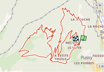

Length
29 km

Max alt
1879 m

Uphill gradient
1777 m
Km-Effort
53 km

Min alt
783 m

Downhill gradient
1778 m
Boucle
Yes
Creation date :
2022-06-18 07:25:41.125
Updated on :
2022-06-18 14:37:49.102
4h00
Difficulty : Difficult

FREE GPS app for hiking
 SityTrail
IGN / Geographical institutes
SityTrail Plus
The world is yours!
About
Trail Mountain bike of 29 km to be discovered at Auvergne-Rhône-Alpes, Savoy, La Léchère. This trail is proposed by XavierFaidix.
Description
2 boucles VAE
Positioning
Country:
France
Region :
Auvergne-Rhône-Alpes
Department/Province :
Savoy
Municipality :
La Léchère
Location:
Pussy
Start:(Dec)
Start:(UTM)
301146 ; 5047914 (32T) N.
Comments